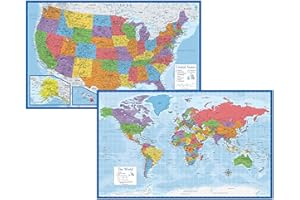
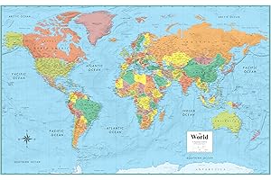
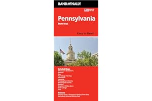
1
Laminated for durability and long-lasting use.
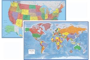
Set includes world and US wall maps.
Each poster measures 18" x 29".
Made in the USA for quality assurance.
Tear-resistant material for added strength.
Ideal for classrooms and home decor.
Updated maps for accurate geographical information.
Average Rating out of 5:
Price Range: $12.97
Size: 18" x 29",18 x 29
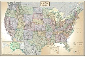
2
Portable folded size: 8x10 inches for convenience.
Vibrant 3D shaded relief for enhanced visual appeal.
Perfect for home, office, or educational settings.
Up-to-date world map with current geographical information.
Printed on durable 24lb paper for longevity.
Ideal for decorating walls and inspiring learning.
Great gift for travelers and geography enthusiasts.
Average Rating out of 5:
Price Range: $9.90
Size: 24 Inch H x 36 Inch W,24 x 36 inches
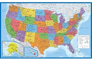
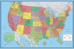
3
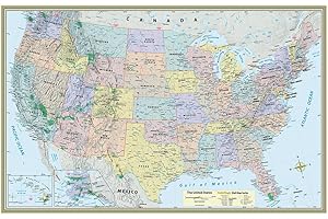
High-quality laminated USA map for durability.
Dimensions: 18 inches tall by 29 inches wide.
Made in the USA with premium materials.
Updated design for accurate information and visuals.
Tear-resistant for long-lasting use and reliability.
Perfect for classrooms, offices, and homes.
Easy to hang and display on walls.
Average Rating out of 5:
Price Range: $9.97
Size: 18" x 29",18 x 29 Inches
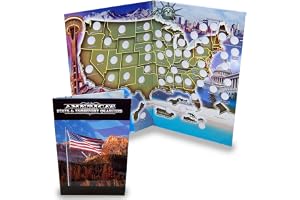
4
Holds all 50 state and 6 territory quarters.
Approximate dimensions: 11"W x 17"L when folded.
Educational and enjoyable for collectors of all ages.
Durable construction designed for long-term use.
Organize your quarter collection in one place.
Beautifully designed map enhances your collection display.
Great gift for history and coin enthusiasts.
Average Rating out of 5:
Price Range: $19.95
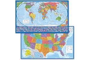
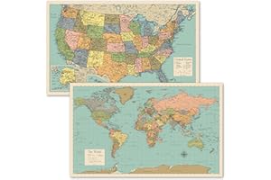
5
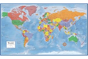
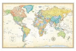
Set of 2 high-quality map posters.
Each poster measures 18” x 29” in size.
Laminated with 3 MIL for durability.
Tear resistant for long-lasting use.
Equal Earth projection shows true relative size.
Perfect for educational or decorative purposes.
Made in the USA for quality assurance.
Average Rating out of 5:
Price Range: $8.97
Color: Blue
6
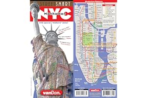
Detailed Manhattan map at 1:32,000 scale.
3-D building illustrations enhance navigation experience.
Laminated for durability and pocket-sized convenience.
Includes subway system and transit information.
Updated quarterly for accurate city navigation.
Shows attractions, hotels, and Broadway theaters.
Designed by Manhattan local Stephan Van Dam.
Average Rating out of 5:
Price Range: $8.95
7
Large 24x36 inch wall map set
Features 3D terrain relief visuals
Laminated for easy dry-erase use
Printed on high-quality 100lb paper
Perfect for home, office, or education
Up-to-date USA and World maps included
Enhances learning and geographic understanding
Average Rating out of 5:
Price Range: $25.00
Size: 24 Inch x 36 Inch,24 x 36 inches
8
Vibrant 3D ocean shading for enhanced visuals.
Durable 3mil lamination for dry-erase use.
Large 24x36 inch size for clear visibility.
Up-to-date map reflects current geopolitical changes.
Perfect for classrooms, offices, or home decor.
Rolled packaging prevents creases and damage.
Excellent gift for travel enthusiasts and learners.
Average Rating out of 5:
Price Range: $19.49
Size: 24 x 36 Inches
9
High-quality laminated U.S. map poster.
Size: 50 x 32 inches, large and detailed.
Includes detailed topography and satellite imagery.
Features labeled states, cities, and areas of interest.
Matte non-glare finish for clear visibility.
Trusted by U.S. government officials, including CIA.
Stylish design fits any home or office decor.
Average Rating out of 5:
Price Range: $10.18
Color: 18 positive
10
Laminated and waterproof for durability.
Highly legible scale: 1:12,500.
Includes attractions, hotels, and Metro information.
Pocket-sized for convenient travel.
3-D building illustrations enhance navigation.
Updated twice a year for accuracy.
Average Rating out of 5:
Price Range: $10.86
11
Vivid colors and 3D terrain relief.
Measures 32" x 50" for impactful display.
Political boundaries and cities are up to date.
Printed on heavy 36lb poster paper.
Durable 3mil double-sided dry erase lamination.
Ideal for home, office, or classroom decor.
Produced by top mapmakers for quality assurance.
Average Rating out of 5:
Price Range: $24.90
Color: 42 positive
12
Extra large 46 x 80 inch wall map.
2024 updated with high level detail.
Features colored countries and clear cities.
Perfect for classrooms and home decor.
Write-on surface, easy to clean.
Delivered crease-less, rolled in a tube.
High quality finish for long-lasting use.
Average Rating out of 5:
Price Range: $39.99
Size: 46 x 80 Inches
13
Large 24" x 36" wall map size.
Ideal for home, office, or educational use.
Printed on durable 24lb poster paper.
Heat laminated on both sides for protection.
UV laminated for dry/wet erase markers.
Features an up-to-date USA map design.
Vibrant colors enhance any room's decor.
Average Rating out of 5:
Price Range: $21.90
Size: 24 Inch x 36 Inch
14
Waterproof and tear-resistant for durability.
Detailed coverage of Arizona and New Mexico.
Includes major national parks and monuments.
Features urban areas like Phoenix and Santa Fe.
Ideal for outdoor adventures and road trips.
Printed on durable synthetic paper for longevity.
Map scale of 1:1,300,000 for accuracy.
Average Rating out of 5:
Price Range: $13.46
15
Waterproof and tear-resistant for durability.
Detailed coverage of Japan's main islands.
Includes inset maps for Okinawa and Ryukyu Islands.
Highlights cultural and historical points of interest.
Clear index for easy city and town navigation.
Comprehensive road network with distance information.
Printed on durable synthetic paper for travel resilience.
Average Rating out of 5:
Price Range: $11.80
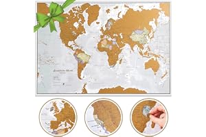
16
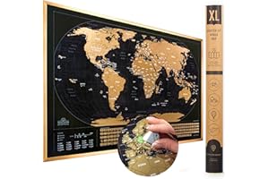
Extra large size: 23 x 33 inches
Scratch off for colorful political map underneath
Detailed world map with country and state borders
Updated in 2024 for best mapping detail
Perfect travel gift for adventurers and explorers
Creaseless delivery in a protective tube
Expertly crafted by internationally renowned cartographers
Average Rating out of 5:
Price Range: $28.99
Size: 23 x 33 Scratch the World,23x33 Inches
17
Regularly updated full-color maps for accuracy.
Clearly labeled highways for easy navigation.
40% larger map ensures better readability.
Indicates county boundaries and key locations.
Includes detailed index for quick reference.
Covers popular areas like Los Angeles and San Diego.
Perfect for road trips and outdoor adventures.
Average Rating out of 5:
Price Range: $11.99
Size: 36" X 45",36 X 45
18
High-quality laminated for durability and longevity.
Large 18” x 29” size for visibility.
Tear-resistant material for added sturdiness.
Clear Miller Map Projection for accurate representation.
Great for educational settings or home decor.
Made in the USA with premium materials.
Perfect gift for students and geography enthusiasts.
Average Rating out of 5:
Price Range: $9.97
Color: Blue
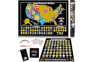
19
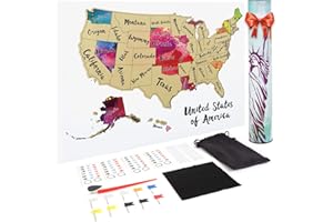
Includes scratch-off USA map and national parks map.
Track travels with 85 landmarks and adventures.
Perfect gift for travelers and outdoor enthusiasts.
Beautiful graphics for a stunning wall display.
Educational tool for classrooms and homeschooling.
100% satisfaction guarantee for your peace of mind.
Comes with pins, stickers, and storage pouch.
Average Rating out of 5:
Price Range: $19.97
Size: 17x24 inches, 12x16 inches
20
Completely up-to-date world map design.
Color-matching relief highlights topographical features.
Centered on Africa for complete country visibility.
Antique-style accents for an upscale appearance.
Rolled map packaged in a sturdy tube.
Product dimensions: 50" x 32".
Copyright 2022, high-quality printing standards.
Average Rating out of 5:
Price Range: $19.99
Size: 50" X 32",50 x 32
21
Updated full-color maps for easy navigation.
Clearly labeled highways and county roads.
Highlights parks and points of interest.
Includes airport and shopping mall locations.
Detailed maps of major Florida cities.
Comprehensive index for quick reference.
Ideal for travelers and residents alike.
Average Rating out of 5:
Price Range: $9.99
Size: 40" x 28",7½ x 4¼ inches
22
Set of 2 educational map posters.
Vibrant illustrations for engaging learning experiences.
Durable 3 MIL lamination for long-lasting use.
Tear-resistant materials ensure poster longevity.
Perfect size: 18" x 29" for visibility.
Made in the USA for quality assurance.
Great for classrooms, playrooms, or home use.
Average Rating out of 5:
Price Range: $12.97
Color: LAMINATED
23
Scratch off to reveal beautiful watercolor designs.
Perfect gift for travelers on any occasion.
Includes 25 practical accessories for exploration.
Durable foil material resists scratches and damage.
Standard size fits easily in any frame.
Convenient cylindrical packaging for easy transport.
Record and display your travel adventures uniquely.
Average Rating out of 5:
Price Range: $9.99
Size: 12"x17",12 x 17 inches
24
Scratch off to reveal vibrant country colors.
Includes flags of 196 countries for exploration.
Beautifully framed design for home decor.
Elegant gift for passionate travelers.
Engaging conversation starter for guests.
Deluxe quality with premium gold coating.
Perfect for various room settings.
Average Rating out of 5:
Price Range: $29.99
Color: Black
25
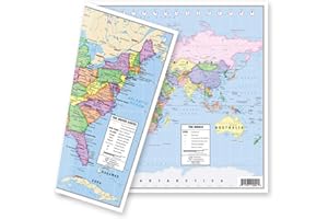
TWO-SIDED MAP with US and World designs.
Vibrant political map in pastel colors.
Detailed United States map with state capitals.
World map showcases clear geographical information.
Perfect for home, office, or classroom use.
Durable 5-mil double-sided lamination for protection.
Made in USA by American Geographics.
Average Rating out of 5:
Price Range: $9.95
Size: 18"Wx13"H,12-3/4" x 17-3/4" Inches
26
Regularly updated for accuracy and relevance.
Large, easy-to-read full-color maps.
48% larger than standard folded maps.
Clearly labeled highways and county boundaries.
Includes schools, parks, and hospitals information.
Detailed mileage and driving times included.
Comprehensive coverage of major New York areas.
Average Rating out of 5:
Price Range: $9.99
Size: 28" x 40",28 x40
27
40% larger map for easy navigation.
Enhanced readability with larger type size.
Regularly updated for accurate information.
Full-color maps for better visibility.
Clearly labeled highways and roads.
Includes parks and points of interest.
Comprehensive coverage of major cities.
Average Rating out of 5:
Price Range: $9.99
Size: 28" x 40",28 x40
28
24x36 size perfect for any wall space.
High-quality laminated for durability and protection.
Ideal for dry-erase markers and easy updates.
Up-to-date map for accurate geographical reference.
Great for educational, office, or home use.
Rolled packaging ensures no creases or folds.
Vibrant colors enhance any room's decor.
Average Rating out of 5:
Price Range: $18.90
Size: 24 x 36 Inch,24 inches by 36 inches
29
Set includes World and USA map posters.
Each poster measures 18” x 29” in size.
Made in the USA for quality assurance.
High-quality 3 MIL lamination for durability.
Tear-resistant material for long-lasting use.
Vibrant colors enhance visual learning experience.
Perfect for classrooms, homes, and educational settings.
Average Rating out of 5:
Price Range: $11.97
Color: LAMINATED